
Notifications

About
Twelve sites have passed the requirements for their inclusion in the preliminary list of World Heritage sites of the United Nations Educational, Scientific and Cultural Organization (UNESCO), and are now candidates for their approval on the official list of World Heritage sites. The move reflects the UAE's efforts to highlight the heritage elements, both tangible and intangible, on the international stage, and to register them on the UNESCO lists, in a way that contributes to marketing them to the world, preserving and restoring them according to the organization's international standards.
Al Dhayah’s Cultural Scene
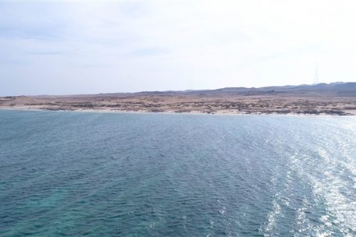
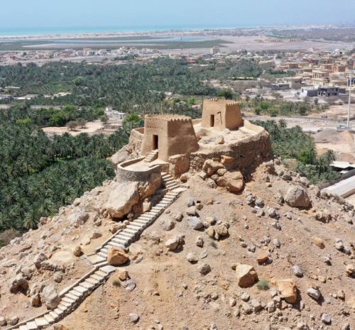 Al Dhayah is one of Ras Al Khaimah’s most impressive and important sites in terms of geographic location and culture. The area is surrounded by steep mountains rising to 850 metres from three directions and overlooking a lake to the west. The Gulf of Al Dhayah has hosted stable communities for thousands of years, and its gravel plains shaped like a crescent has witnessed agriculture activities towards the coast. The area has various natural landscapes, heritage sites and historic locations, which include a lake, palm trees gardens, and Al Dhayah Fort.
 Julfar City (The Commercial Centre)
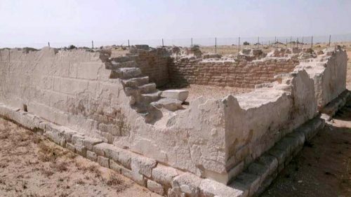
 Julfar City, part of the Musandam Peninsula and close to the Hormuz Strait, is located on a sedimentary plain separated by limestone quarries from the Gulf coast. Due to its geographical location in a drifting area between Wadi Beeh and Wadi Haqil, it has access to rainwater and sediment pools from the steep mountains, meaning that it has fertile soil suitable for agriculture. These fertile plains have led to the establishment of Julfar Commercial City. Due to the frequent natural changes to Julfar’s environment and the use of land, many key heritage sites have been closely linked to Julfar City. The three sites in Kush, Al Mataf and Al Nodoud, Ras Al Khaimah, were identified as Julfar ports and commercial centres during various periods of the Islamic era. The city had a massive wall, which was part of an impressive fortification system securing its ports and palm trees gardens.
 The Pearl Trade City on the Red Island
 The original 45-hectare island was located along the Gulf close on the southern coast of Ras Al Khaimah. Its eastern and southern parts were connected to the mainland and constantly accessible. To the east, the island overlooks the desert and currently, two surveillance towers protect it. The towers also secured drinkable water wells, and water was previously brought to the island by donkeys. The city’s maritime environment provided marginally salty water for household use only. The small alleys on the Red Island contain houses with yards, markets, mosques and a fort, along with surveillance towers. Al Shamal Al Shamal is a rich heritage site stretching from Ras Al Jabal for over three kilometers. The area is characterized by gravel plains and Acacia forests overlooking limestone quarries in Ras Al Khaimah
 Shamal
 Shamal is a rich heritage site stretching from Ras Al Jabal for over three kilometers. The area is characterized by gravel plains and Acacia forests overlooking limestone quarries in Ras Al Khaimah. To the west, Al Shamal overlooks vast palm tree gardens on the fertile plains of Wadi Beeh and Wadi Hail. The cultural site has many settlements and over 100 cemeteries dating back to prehistory, as well as a palace dating back from 1600 to 2000 BC, and other sites dating back to the Late Bronze Age (1600 to 1300 BC) and the Middle Islamic Era (13th to 16th century AD). The Al Shamal area has contributed to the unique cultural traditions that evolved on the crossroads of the ancient trade routes along the Gulf, the Indian Ocean and the south-eastern part of the Arabian Peninsula.
Umm an-Nar Island
 The present size and shape of the island is different from what it used to be, as it has been enlarged by land reclamation and dredging. Despite extensive land reclamation the archaeological sites are well protected and preserved. The site is fenced off by a sound concrete wall with a total length of about 1760 meters. Access to the island at the time of preparing this document is through this bridge, but still restricted to pass holders only. The archaeological area comprises a settlement and a cemetery.
 Coastal sabkha - Abu Dhabi
 The area of the coastal sabkha of Abu Dhabi is located on the southern coast of the Arabian Gulf, in the United Arab Emirates; west of the emirate of Abu Dhabi. It has been developed over the past 7000 years due to the wind erosion of pre‐existing dunes and progradation of subaqueous, intertidal, and supratidal carbonate sediments.
 Al Bidya Mosque
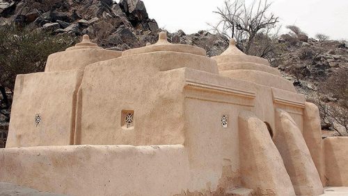 This mosque is named as "Al Bidya Mosque" due to its location in Al Bidya area.
Al Bidya is a large village in the Fujairah Emirate that form part of several other villages in the area including Al Fai, Al Jubail, Haqeel, Twai Bin Saada, Al Hara and Al Telae. Until recently, the population of these villages used Al Bidya Mosque for the Friday prayer "Al Jumu'ah".
This mosque is named as "Al Bidya Mosque" due to its location in Al Bidya area.
Al Bidya is a large village in the Fujairah Emirate that form part of several other villages in the area including Al Fai, Al Jubail, Haqeel, Twai Bin Saada, Al Hara and Al Telae. Until recently, the population of these villages used Al Bidya Mosque for the Friday prayer "Al Jumu'ah". Ed-Dur Site
 Ed-Dur Site is one of the of the largest archaeological sites in the United Arab Emirates, overlooks Al Beidha Lake. It is naturally surrounded by a series of high sand dunes that protect it from the northern offshore wind prevailing in the region.
 Khor Dubai
 Khor Dubai (Dubai Creek in English) is a natural seawater inlet of the Arabian Gulf located in the heart of Dubai with 14 kilometres length and between 100-500 meters width that runs South-East and ends at Ras Al-Khor wildlife Sanctuary. The creek divides the city into two parts: Bur Dubai and Deira, and has played a major role in the economic development of the region throughout history.
 Sir Bu Nair Island
 The protected island Sir Bu Nair is one of the most important marine protected areas in the UAE for its contents of significant environmental elements, such as its geological formations, natural flora and Marine birds, island characterized by the nature scenery and sandy beaches that have been taken by sea turtles as a center for breeding.
 Sharjah: The Gate to Trucial States
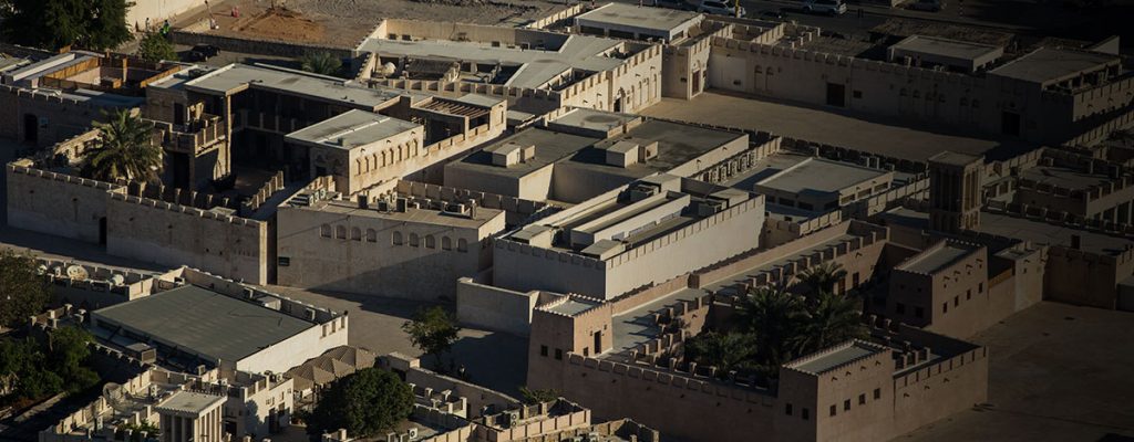 Sharjah, including its old port and old airport, is located in the old part of the Emirate of Sharjah in the northern United Arab Emirates. According to historical sources, this location contributed to the development of trade, Sharjah port is particularly significant as main gate to the Trucial States.
 The central region of Sharjah
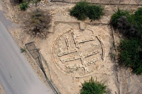
The central region of Sharjah is characterized by a chain of high outcrops located to the West of the Hajar Mountain range, at an approximate distance of 55 kilometers from both the Arabian Gulf to the West and the Gulf of Oman to the East.. The eastern slopes benefited from water catchment coming from the Hajar Mountains, thus enabling a repeated human occupation over more than 250 000 years in this area.
